 Filter: Categories of Wisconsin Historical Images
Filter: FULL_DATE of 1911-10
Filter: Categories of Wisconsin Historical Images
Filter: FULL_DATE of 1911-10

| Date: | 10 1911 |
|---|---|
| Description: | Section 1 of a Sanborn map of Osceola. |

| Date: | 10 1911 |
|---|---|
| Description: | Section 2 of a Sanborn Map of Osceola. |
| Date: | 10 1911 |
|---|---|
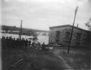
| Description: | View towards river with high water flooding over several buildings behind a group of people in the foreground. Identified as the flood of the Black River i... |

| Date: | 10 1911 |
|---|---|
| Description: | This map shows lot numbers, building lines, roads, trees, and Indian mounds. Relief is shown by contours. Includes manuscript annotations marking parks. |
If you didn't find the material you searched for, our Library Reference Staff can help.
Call our reference desk at 608-264-6535 or email us at: